
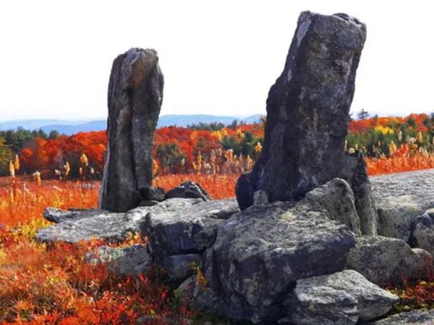
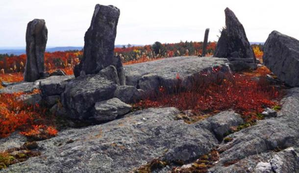
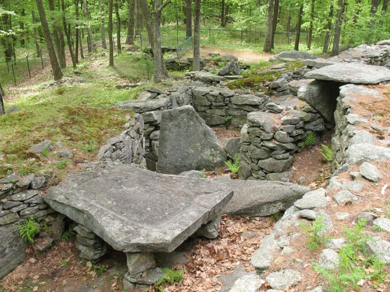
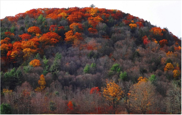
I was hiking in Heath, Massachusetts, and taking pictures of the foliage. I had no idea that I would find these stones, but once I got home, I found such little information about the site. All the pictures were outdated, and the information about the site, that was available didn’t offer many answers. The site is falsely called a stone circle when it isn’t a circle at all, the main standing stones form an offset rectangle, but the site stretches to the north and south down the ridge.
George Sheldon wrote about Burnt Hill in his “History of Deerfield” that the Pocumtuck Indians called the area Sunsick Hill which translates to “Stone Place” Hill. This means to me that this site was there before the Indians or I believe the Pocumtucks who practiced Manitou would have named this place something more special if they built it, but this is just my opinion.
Allan Healy in his 1965 “History of Charlemont” states that Burnt Hill was deforested in prehistoric times and that the Pocumtucks used fire to clear the undergrowth in the hill to help cultivate low bush blueberries. The infamous Mohawk Trail abuts the southernmost end of Burnt Hill.
The evidence
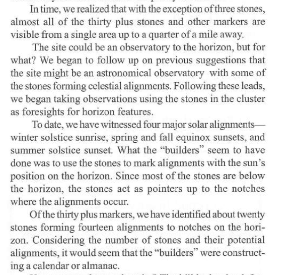
A study was done in 2000, by Colgate Gilbert and the New England Antique Research Association. All of this information was published in the Heath Herald I will provide the links to both articles about the site. The standing stones nearby have astronomical alignments according to the study done by NEARA. The stone structure matches up to astronomical alignments from over 1,000 years ago or how the sky was 1,000 years ago. Further analysis needs to be done. Winter and Summer Solstices can be seen clearly at the Heath site as well as other astronomical alignments. Here is a quote from Mr. Gilbert’s study.
“What the builders seem to have done was to use the stones to mark alignments with the sun’s position on the horizon. Since most of the stones are below the horizon, the stones act as pointers up to the notches where the alignments occur. Of the thirty-plus markers, we have identified about twenty stones forming fourteen alignments to the notches on the horizon. Considering the number of stones and their potential alignments, it would seem that the builders were constructing a calendar or almanac.”
The Pocumtucks are an extinct tribe, making historical information about the Pocumtucs very hard to find. However, the fingerprints they left across New England are undeniable. Mount Greylock, the highest mountain peak in Massachusetts, is named after a famous Pocumtuc warrior. The Pocumtucs were scattered, some went to Wisconsin others, went to Canada, and New York.
I believe Burnt Hill is a very sacred place for the many native tribes around here, not just one. A little under 2 miles separates Mount Pocumtuc and Burnt Hill. This gap creates a notch in the horizon, and I will explain why this gap on the horizon has significance to Native Americans of New England.
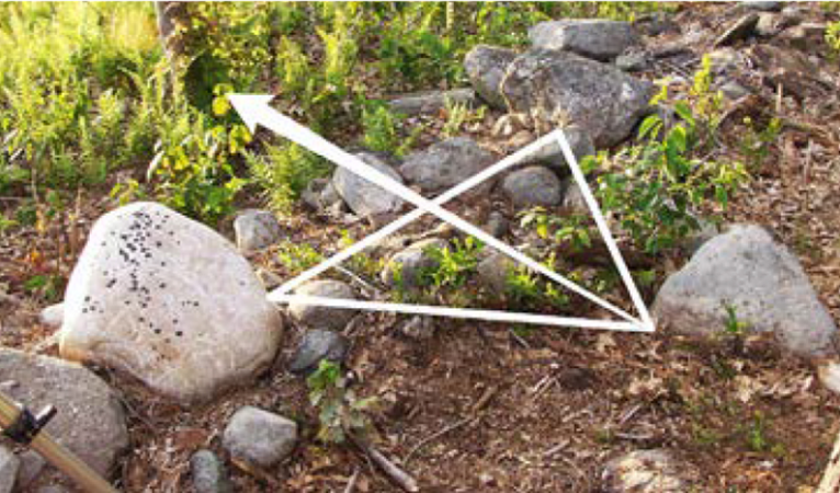
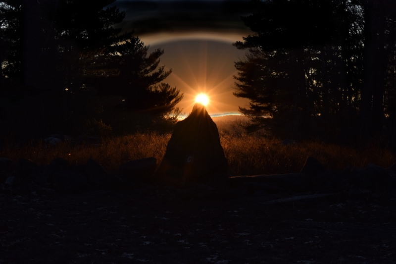
15.5 miles away from Burnt Hill is the Sacred Hill Prayer site in Turners Falls Massachusetts (pictured above). At the Scared Hill Prayer site stone formation is what archeologists assumed was a broken stone wall, but it is an ancient triangular viewing position. These rocks directed ancients to look toward Mount Pocumtuc. And if you stand at this precise location on August 12-13th and look towards the horizon, the sun perfectly sets in the notch on the horizon in the gap between Burnt Hill and Pocumtuc Mountain as it also did in ancient times because of the suns cycle. (pictured below)
The sunset on August 12-13th is a calendrical indicator of the highest concentration of the month-long Perseid Meteor Shower. For many indigenous people of New England, this event represents the travel of spirits of the deceased home of the Kautantowitt (Creator.) I plan to record this event as it happens in August of this year. I am sure you are aware this month has significance to Native Americans. The neighboring Narragansetts of Rhode Island host a festival during this time that was first documented 350 years ago.
American Stonehenge which is about 30 miles to the NW in New Hampshire and has astronomical alignments has been carbon-dated to around 4,000 years ago and the builders of American Stonehenge are still unknown. The standing stones on Burnt Hill seem to be much older, they are crudely propped and placed instead of intricate stonework as we see at American Stonehenge. Some of the stones on Burnt Hill looked shaped, but this site has never been properly investigated.
I chose to focus my research on the Pocumtuck tribe of Massachusetts because I grew up in the territory where the Pocumtuck people use to live and after finding some standing stones on top of Burnt Hill in Heath, Massachusetts. I researched who may have built these standing stones and my research led me to the Pocumtuck people. I read Allan Healy’s History of Charlemont where he talks about how the Pocumtuck used fire to clear the top of Burnt Hill of brush before the blueberry season and the standing stones are located on an active blueberry farm called The Benson Place. I also read George Sheldon’s History of Deerfield where he talks about how the Pocumtuck Indians called Burnt Hill, Sunsick Hill which translates to “Stone Place” Hill and I have been fascinated with the Pocumtuck people ever since.
Who are the Pocumtuck People?
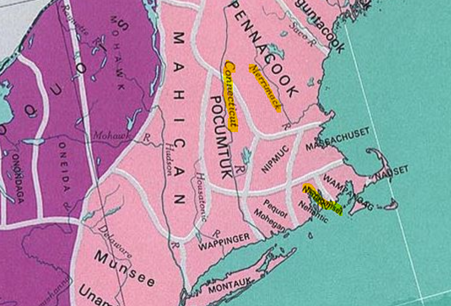
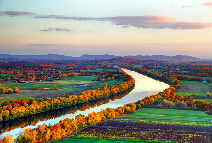
The Pocumtuck tribe of the Connecticut River Valley in Massachusetts is an Algonquin agricultural tribe that flourished in some of the richest farmland in New England on mostly maize, beans, and squash. The Pocumtuck tribe was roughly 5,000 strong in 1600 before King Philips War, but their population was displaced and decimated by the end of the war. The Pocumtuck people used the Quinnitukqut (long river) or what is now known as the Connecticut River for trading to the North and South. They used the Mohawk Trail to trade to the East and West. Around 600 were estimated to survive the war and disease that came with King Philips War. After King Philips War, the Pocumtuck relocated, some joined Mahican village Schaghticook in Hudson River Valley, and others relocated to the Abenaki village in St. Francois du Lac, Quebec.
The Pocumtuck Indians set up trading alliances with the English and French, but the Pocumtuck’s most famous alliance was with William Pynchon the English colonists who founded Springfield, Massachusetts. According to the Handbook of American Indians North of Mexico, the Pocumtuck people were powerful tribes that ruled over all other river tribes in the Connecticut River Valley like the Agawam, Nonatuck, Nipmuck, Woronock, and Podunk.
What were the Pocumtuck’s religious beliefs or practices?
There is not much written about the Pocumtuck people’s culture or religious beliefs, but it is logical to assume that the Pocumtuck people practiced Manitou. Manitou is an animistic religion in which the Pocumtucks believe spiritual beings exist in natural phenomena like a giant boulder, mountain, waterfall, or any geographical feature are beings with rich backstories and meaning to the Pocumtuck people. These beings are represented as religious figures or significant omens, and all of them are controlled by the Great Manitou who creates balance on earth.
This leads us back to the potential Pocumtuck prehistoric archaeological site that is located on private property in Heath, Massachusetts. The site consists of over thirty standing stones. Some stones have fallen over time, and it is known as the Burnt Hill stone circle, but it is not a circle. This site has very little research or field studies conducted because it resides on private property. I did not include pictures or write much about the standing stones because there is not enough evidence to claim this site was built by the Pocumtuck people. However, a study was conducted by Colgate Gilbert in 2002 on Burnt Hill, and for reasons unknown, never published. I found a newspaper article from the Heath Herald in 2002 about the Burnt Hill Standing Stones where Colgate Gilbert writes about his findings on Burnt Hill.
Right next to Burnt Hill is Pocumtuck Mountain, Asa White purchased the mountain in the 1700s and named it Burnt Hill. Why? Why call this mountain Burnt Hill? Because the Pocumtuck people cultivated low bush blueberries that grow naturally on Burnt Hill. The Pocumtuck people would set the hill ablaze to remove weeds and unwanted plants to ensure the blueberries would be able to grow unrestrained in the next growing season. The Pocumtuck people called this mountain Sunsick hill, which translates to stone place hill, and Burnt Hill is located on the tail end of the famed Mohawk trail. According to the astronomical survey done by Colgate Gilbert and the New England Antiquities Research Association, the celestial alignments observed on Burnt Hill would match the sky of 1,000-3,000 years ago. There is no evidence to suggest that anyone, aside from the Pocumtuck people, controlled, lived, and thrived in this region 1,000-3,000 years ago.
What is the history of the Pocumtuck people, and where are their artifacts?
The Pocumtuck lived in some of the most fertile farmland in New England, which made them an agricultural culture like many other Algonquin tribes in New England. The Pocumtuck also took advantage of seasonal fish runs up the Connecticut River and an endless amount of game to hunt. The Pocumtuck’s territory in Massachusetts stretched from modern-day Hampshire County in southern Massachusetts on the border with Connecticut to Franklin County on the New Hampshire, Massachusetts border.
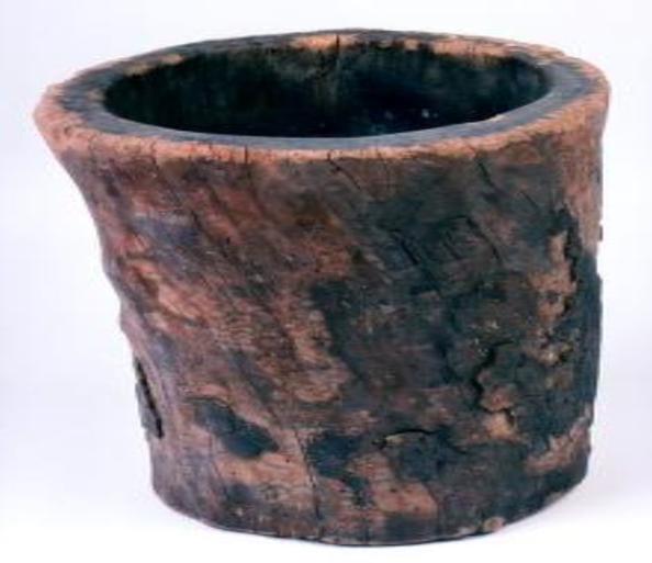
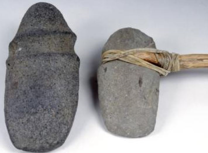
The Pocumtuck people made their own tools such as basalt hoes for farming, wooden corn mortars from hollowed trees for storing corn, stone axes, stone gouges, and bifacial blades. Many of these artifacts reside in local museums or associations like the Pocumtuck Valley Memorial Association. Further research into whether or not British soldiers at the time carried these unique sword knives or if the weapons were sold to the Pocumtuck people by the French would shed light on who wielded this sword knife. How did the Pocumtuck warriors know where the British convoy was going to be? Did the French offer the Pocumtucks the intel on the location of the convoy so the Pocumtucks could conduct an attack against their foes? Digging deep into the historical record from both the mainstream sources and knowledge gained from native tribes using the Poly-Communal method could be implemented to answer many questions these artifacts conjure up.

The Pocumtucks lived in fortified dwellings due to constant and endless war with the Mohawk Indians in neighboring New York. The Mohawks fought the Pocumtucks over land that is now the Berkshire Mountains because this land was rich with game animals that were used in the lucrative fur trade of the 1600s. When the Dutch arrived in the Connecticut River Valley in 1610, they caused the demand in the fur trade to rise, and the war between the Mohawks and the Pocumtucks intensified. After the Pocumtucks suffered heavy losses to the Mohawk, the Pocumtucks allied with the powerful Mahicans. Fearing an all-out war would break out in the region, the Dutch organized a peace treaty between the Pocumtucks and the Mohawks in 1617.
The peace treaty ended abruptly in 1624 when the Mohawks found out that the Dutch and the Mahicans were attempting to open trade up into the St. Lawrence Valley with the Hurons and Algonkins, who are both longtime enemies of the Mohawks. After finding out the the secret plan, the Mohawks decimated the Mahicans and forced them out of the Hudson River Valley by 1628. Once the Mohawks claimed victory over the Mahicans, they targeted allies of the Mahicans in the region, leaving the Pocumtucks to become refugees of war. The Pocumtuck people are now known as an extinct tribe, which is why it is hard to find information about the Pocumtuck people, although a small group of Pocumtuck still live in Deerfield, Massachusetts.
I chose to focus on a weapon that has the handle of a sword but the blade of a knife, found by a French farmer in South Deerfield, Massachusetts, in 1765. The creek where the sword was found is known as “Bloody Creek” because of a deadly attack carried out by Pocumtucks in 1665 on an English grain convoy. The sword knife is 10 inches long and a little under an inch wide, the handle is wood, and the blade is iron. According to the Pocumtuck Valley Memorial Association, the pommel of the sword knife is consistent with small European swords.
The Pocumtucks were known to trade with the French, which could explain where the Pocumtucks acquired this weapon.
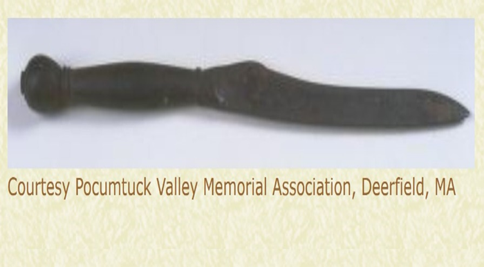
The weapon may also have been left behind by a member of the English convoy. Regardless of who the sword belonged to, this artifact marks a crucial time in the history of the Pocumtuck people because it was the first time the Pocumtuck people started to fight back against the English settlers encroaching on their lands. This artifact also encapsulates one of the most painful thorns in the side of the British empire, the French arming native tribes that the British were trying to colonize.
An archaeological research method that has been used in the past to study the Pocumtuck Fort in Deerfield, Massachusetts, was first proposed by Siobhan Hart, a process she coined “Poly-Communal Archaeology.” Poly-Communal archaeology is crucial for investigating tribes in New England because it takes the approach that most of the history of New England tribes has been erased from history by colonization. Poly-Communal archaeology incorporates local native tribes into research projects, while other archaeological methods may inadvertently exclude or ignore cultural values.
The Poly-Communal archaeological method would be the best method to acquire the sword knife from the creek where it was found. The specific location of this artifact is unknown, but all of the land surrounding the creekbed where it was found is now private land. The Poly- Communal approach could allow researchers to get the full context of the historical events leading up to the attack by the Pocumtucks on the British convoy because it is based on getting information from all sides of the historical event. Currently, the historical record describes the attack by the Pocumtucks as a ruthless attack carried out by savages while leaving out the why. By using the Poly-Communal approach, we can gather direct information from the native tribes offering more historical context to the Pocumtuck attack.
In conclusion, I believe that any time historians take the time to highlight a culture that isn’t researched much. Or even worst, an ethnic group that systematically has had their history erased from the historical record like the Pocumtuck has a positive impact on the Pocumtuck people because it helps preserve culture. Anthropological methods like Poly-Communal Archaeology is significant to the profession of anthropology because they can be used to resurrect native tribes that are falsely labeled extinct or have been lost to the historical record.
There are brief mentions in old books, and there has been this false notion for the last two decades that you can’t visit the site, but if I, a mere researcher and student found out that this site was not off-limits in just a few days then it is obvious to me that no one around here will ever investigate these stones. I just cannot let this happen nor can I explain my attraction to this site. All of this started when I was in High School and a friend asked me if I wanted to hike from Mt. Pocumtuc to Burnt Hill, to take images of these standing stones. Needless to say, that day changed my life, and I have been researching Burnt Hill ever since, I have to know who built this site!
Written by Joziah Thayer
This is parts one and two of the story about Burnt Hill and Colgate Gilbert’s study in the Heath Herald.
The Herald: both articles are on page 3 continued to page 15 https://heathherald.org/uploads/3/4/6/3/34634026/vol_22-3_augsep_2001-compressed.pdf
The Herald: part 2 pg.3-15 https://heathherald.org/uploads/3/4/6/3/34634026/vol_22-4_octnov_2001-compressed.pdf
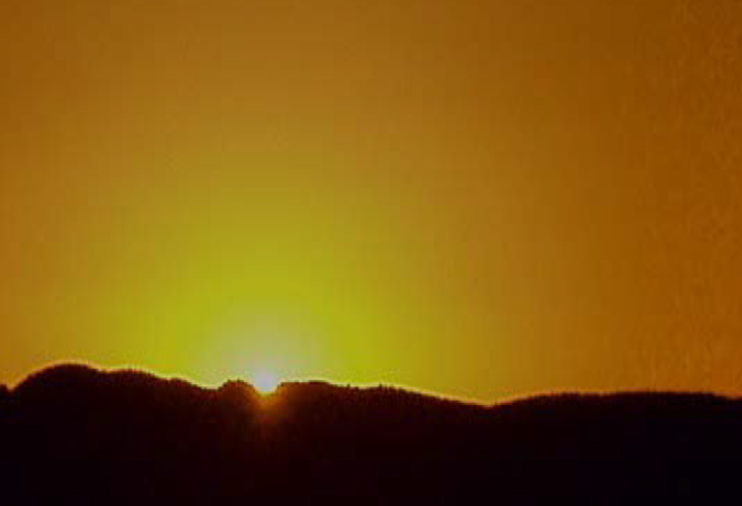
Source for the Sun image:
Tribal Historic Preservation Program Annual Report 2017
Boudillion, D. V. (n.d.). Burnt Hilll Site Visit. Burnt hill. Retrieved January 28, 2022, from http://www.boudillion.com/burnthill/burnthill.html
Hart, Siobhan M, “High Stakes: A Poly-Communal Archaeology Of The Pocumtuckk
Fort, Deerfield, Massachusetts” (2009). Doctoral Dissertations 1896 – February 2014. 47. https://doi.org/10.7275/5645737 https://scholarworks.umass.edu/dissertations_1/47
Hart, S. M. (2018). Colonialism, community, and heritage in Native New England, 298–302. https://doi.org/10.2307/j.ctvx07445
“Handbook of American Indians North of MEXICO; Ed : Hodge, FREDERICK Webb, 1864-1956 : Free Download, Borrow, and Streaming.” Internet Archive. Washington, Govt. print. off, October 1, 1907. https://archive.org/details/handbookamindians01hodgrich/page/270/mode/2up.
“James D. DRAKE. King Philip’s War: Civil War in New ENGLAND, 1675–1676. (Native Americans of the Northeast: Culture, History, and the Contemporary.) Amherst: University of Massachusetts Press. 1999. Pp. Vii, 257. The American Historical Review, 2000. https://doi.org/10.1086/ahr/105.4.1294.
King, H. R., & DeForest, J. W. (1965). History of the Indians Of Connecticut: From the earliest known period to 1850. Ethnohistory, 12(3), 262. https://doi.org/10.2307/480516
